

VisitSantaBarbara.com
 |
|
(805) 563-8002 |
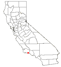
Santa Barbara, California Santa Barbara is a city in California, United States. It is the county seat of Santa Barbara County, California. As of the 2000 census, the city had a total population of 92,325. The metropolitan area—which includes the cities of Goleta and Carpinteria; the unincorporated communities of Montecito, Summerland, Isla Vista, and Hope Ranch; and adjacent areas—has a population of approximately 200,000. |
|
Geography Santa Barbara is located about 85 miles northwest of Los Angeles, along the Pacific coast. This stretch of coast along southern Santa Barbara County is often referred to as the "American Riviera" because of its Mediterranean climate. The Santa Ynez Mountains, an east-west trending range, rise dramatically behind the city, with several peaks exceeding 4,000 feet. Covered with chaparral and with sandstone outcrops, they make a famously scenic backdrop to the town. Nearer to town, and directly east and adjacent to Mission Santa Barbara, is a hill known locally as the "Riviera" or "Alameda Padre Serra" (shortened APS) for the street that traverses it, which is built up with expensive homes. The city sustained heavy damage in an earthquake on June 29, 1925, which was followed by substantial rebuilding. Much of the architecture in the city is Spanish Colonial in style, although much of it was actually constructed starting in the early 20th century in connection with the Mission or Spanish Revival movement. White buildings with terra cotta tile roofs are a trademark sight. The city has enacted strict ordinances to prevent erosion of this image, with some success. For example, there are no billboards anywhere in town, and none at all on the main freeway through town for almost twenty miles in both directions; in addition there is a strict sign ordinance for businesses, with no excessively large lettering allowed. According to the United States Census Bureau, the city has a total area of 107.3 km² (41.4 mi²). 49.2 km² (19.0 mi²) of it is land and 58.1 km² (22.4 mi²) of it (54.17%) is water. this is because the official city limit extends exactly four miles south into the ocean, and in addition a long "finger" of the city extends out to sea and again inland, in order to make Santa Barbara Airport (adjacent to the University of California, Santa Barbara [UCSB]) contiguous with the city. |
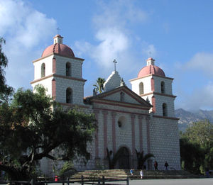 Mission Santa Barbara, known as "the queen of the missions". |
There were 35,605 households out of which 24.3% had children under the age of 18 living with them, 39.8% were married couples living together, 9.5% had a female householder with no husband present, and 46.8% were non-families. 32.9% of all households were made up of individuals and 11.4% had someone living alone who was 65 years of age or older. The average household size was 2.47 and the average family size was 3.17. In the city the population was spread out with 19.8% under the age of 18, 13.8% from 18 to 24, 32.3% from 25 to 44, 20.4% from 45 to 64, and 13.8% who were 65 years of age or older. The median age was 35 years. For every 100 females there were 97.0 males. For every 100 females age 18 and over, there were 95.0 males. The median income for a household in the city was $47,498, and the median income for a family was $57,880. Males had a median income of $37,116 versus $31,911 for females. The per capita income for the city was $26,466. About 7.7% of families and 13.4% of the population were below the poverty line, including 16.8% of those under age 18 and 7.4% of those age 65 or over. If one compares the per capita income to the actual cost of living, the number of people living below the poverty line is considerably higher. In 2002, the cost of buying a 2200 ft² (200 m²), 3 bedroom, 3 bathroom house could easily reach $2,000,000. Rents for a 1100 ft² (100 m²), 2 bedroom, 2 bathroom apartment were in the $2000-$2200 per month range. In June 2004, the median home price passed $1,000,000 for the first time. Santa Barbara also has traditionally (since the 1930s) had a large homeless population, due in part to the high cost of living. In 2006, according to the California State Department of Finance, the population of the city had shrunk to 89,548, with the city of Santa Maria, on the northern edge of Santa Barbara County, becoming the most populous city in the county. A common reason given for the demographic shift is that homes in Santa Maria cost approximately half as much as homes in Santa Barbara. |
|
|||||||||||||||||||||||||||||||||||||||
|
||||||||||||||||||||||||||||||||||||||||
Government The city's representative is Lois Capps (D). Mayor:
City Council members:
|
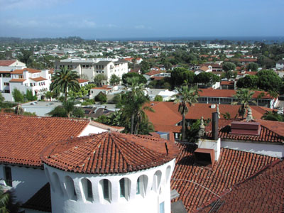 Santa Barbara, looking towards the harbor from the top of the County Courthouse, showing the distinctive red-tiled roofs |
Media Santa Barbara has two daily newspapers: The Santa Barbara News-Press, which has a circulation of about 39,000 and the Santa Barbara Daily Sound, a free daily. The News-Press was sold by the New York Times Company in 2000, and is now independently owned by Wendy P. McCaw, a local resident and outspoken environmentalist. Other local media include the Pacific Coast Business Times, a weekly business journal covering Santa Barbara, Ventura, and San Luis Obispo Counties, Santa Barbara Independent, an arts and entertainment newsweekly, Edhat Online Magazine, a hyperlocal website, and Coastal Woman, a quarterly glossy magazine for local women, as well as television stations KEYT 3, an ABC television affiliate and KPMR 38, a Univision affiliate. |
|
Museums
Santa Barbara is home to a vibrant artistic community, and the Santa Barbara Museum of Art is home to a significant permanent collection. Other art venues include the University Art Museum on the UC Santa Barbara Campus, various private galleries, and a wide variety of art and photography shows. The Santa Barbara Museum of Natural History is located immediately behind the Santa Barbara Mission in a complex of charming, mission-style buildings set in a delightful park-like campus. The Museum offers outstanding indoor and outdoor exhibits and a state-of-the-art planetarium. The Santa Barbara Maritime Museum is located at 113 Harbor Way (the former Naval Reserve Center Santa Barbara) on the waterfront.
Parks Santa Barbara has many parks, ranging from small spaces within the urban environment to large, semi-wilderness areas which remain within the city limits. Some notable parks within the city limits are as follows:
|
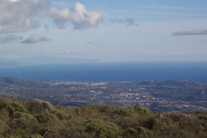 A view of Santa Barbara from the Santa Ynez Mountain Range |
Some notable parks and open spaces just outside of the city limits include:
|
|
Performing arts
Santa Barbara boasts numerous performing art venues, including the Arlington Theatre, the largest performance venue in Santa Barbara; the Lobero Theatre, a historic building and favorite venue for small concerts; the Granada Theater, originally built by a contractor named CM Urton in 1920, now the tallest building downtown (the theater is currently under-going a serious remodel and is not being used); and the Santa Barbara Bowl, a concert space nestled in the foothills.
The city is considered a haven for classical music lovers with a symphony orchestra and many non-profit classical music groups (such as CAMA). The Music Academy of the West, located in Montecito, hosts an annual music festival in the summer, drawing renowned students and professionals.
Tourist attractions Santa Barbara is a year-round tourist destination renowned for its warm weather, downtown beaches, and Spanish architecture. In addition to the city's cultural assets, several iconic destinations lay within the city's limits. Mission Santa Barbara, "The Queen of the Missions," is located in Santa Barbara. It was founded on December 4, 1786 on a rise about two miles inland from the harbor, and is maintained as an active place of worship, sightseeing stop, and national historic landmark. The Santa Barbara County Courthouse, a red tiled Spanish-Moorish structure, provides a sweeping view of the downtown area from its open air tower. The Presidio, a Spanish military installation built in 1782, was central to the town's early development and remains an icon of the city's colonial roots. Also famous is the annual Fiesta (originally called "Old Spanish Days"), celebrated every year in August. Fiesta, in Santa Barbara, is synonymous with food, music, and riotous parties, ranging from the annual Covarrubias Adobe Pre-Fiesta Tea, to the Fiesta Pequeña on the steps of the Mission. Fiesta is hosted by the Native Daughters of the Golden West and the Native Sons of the Golden West in a joint committee called the Fiesta Board. Fiesta was originally started as a tourist attraction, like the Rose Bowl, to draw business into the town in the 1920's. 80 years later, it has become a several-day-long bash of Mexican food, Spanish dancing, and traffic tie ups all along State Street. Flower Girls and Las Señoritas are another attraction of Fiesta, as they march and participate in both Fiesta Pequeña (the kickoff of Fiesta) and the various parades. Flower Girls is for girls under 13. They throw roses and other flowers into the crowds. Las Señoritas are their older escorts. Many Señoritas join the Native Daughters at the age of 16. In recent years, the Santa Barbara International Film Festival (SBIFF), another local non-profit, has also become a major draw bringing over 50,000 attendees during what is usually Santa Barbara's slow season in late January. SBIFF hosts a wide variety of celebrities, premieres, panels and movies from around the world and runs for 10 days. The annual Summer Solstice Parade draws up to 100,000 people. It is a colorful themed parade put on by local residents, and follows a route along State Street for approximately one mile, ending at Alameda Park. Floats and costumes vary from the whimsical to the outrageous; parties and street events take place throughout the weekend of the parade, which is invariably the first weekend after the solstice. |
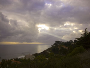 A view of a Santa Barbara sunset looking over the ocean. |
||||
|
|||||
Santa Barbara and the immediately adjacent area is home to several colleges and universities:
Local children go to schools in the Santa Barbara and Hope school districts. |
Santa Barbara, looking northeast from above Santa Barbara City College, towards the harbor |
Santa Barbara is bisected by U.S. Route 101, a primary transportation corridor that links the city to the rest of the Central Coast region. The Santa Barbara Airport offers commercial air service. Amtrak offers rail service through the Coast Starlight and Pacific Surfliner trains at the train station on State Street. The service is slow, though scenic; like much of Amtrak's network, it operates over freight lines that limit speed and produce delays. The Metropolitan Transit District (MTD) provides local bus service across the city, and Greyhound bus stations are located downtown and in nearby Goleta. Electric shuttles operated by MTD ferry tourists and shoppers up and down lower State Street and to the wharf. |
|
Sister Cities
Dingle, Ireland, was established as a Santa Barbara Sister City in Spring 2003.
The Santa Barbara/Palma de Mallorca Sister City affiliation was started in 1986.
Puerta Vallarta, Jalisco, Mexico, became a Sister City in 1972.
San Juan became a Sister City in 2000.
The Toba City/Santa Barbara affiliation was begun in 1966, and there have been several visits by citizens and officials of both cities.
Weihai, in Shandong Province, China, became a Sister City to Santa Barbara in 1993.
Yalta, Crimea, Ukraine, became Santa Barbara's sixth Sister City in November 1987.
Santa Barbara is the birthplace of:
The following notable people were not born in Santa Barbara, but grew up there:
Celebrities who have or had owned homes in Santa Barbara and the surrounding communities include:
External links
|
Santa Barbara, looking west-northwest from the County Courthouse tower, with Mission Santa Barbara and San Marcos Pass in the distance |